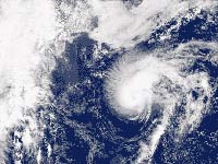
New storm forms in the Gulf of Mexico
A tropical depression has strengthened into Tropical Storm Karen in the open Atlantic Ocean, where it posed no immediate threat to land, and a new tropical depression formed in the southwestern Gulf of Mexico.

At 11 p.m. EDT Tuesday (0300 GMT Wednesday), Karen was centered about 1,355 miles (2,180 kilometers) east of the Windward Islands, with top sustained winds near 40 mph (64 kph), the National Hurricane Center said. It was moving toward the west-northwest near 14 mph (23 kph) and was expected to continue this motion over the next 24 hours.
Tropical storm force winds extend outward up to 70 miles (115 kilometers) from Karen's center. On its current course, it is expected to hit two troughs, though forecasters are unsure how they will affect Karen.
The 13th depression of the season formed Tuesday, but remained weak, forecasters said. A tropical storm watch may be required for a portion of the Gulf Coast of Mexico on Wednesday. At 11 p.m. the storm was located about 165 miles (265 kilometers) east southeast of Tampico, Mexico and moving toward the west near 5 mph (8 kph) with top sustained winds near 30 mph (48 kph).
It was expected to slowly gain strength during the next 24 hours.
Subscribe to Pravda.Ru Telegram channel, Facebook, RSS!


