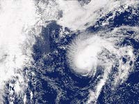
New tropical depression forms in Atlantic
A tropical depression formed in the open Atlantic, while Tropical Storm Jerry weakened to a depression then dissipated in cooler waters.

The twelfth tropical depression of the season was expected to develop into Tropical Storm Karen sometime Tuesday, but should not threaten land over the next several days, said senior hurricane specialist James Franklin.
As of 11 p.m. EDT (0300 GMT), the depression was centered about 1,700 miles (2,735 kilometers) east of the Southern Windward Islands, with top sustained winds near 35 mph (56 kph), the National Hurricane Center said. It was moving toward the west northwest near 16 mph (25.75 kilometer) and was expected to continue this general motion over the next 24 hours.
Jerry, which formed Sunday, broke up Monday night. Forecasters expected it to be absorbed by a larger non-tropical low pressure system by Tuesday morning.
At 11 p.m. EDT (0300 GMT), Jerry was centered about 705 miles (1,135 kilometers) northwest of the Azores, with top sustained winds near 45 mph (72.4 kph), the National Hurricane Center said. It was moving toward the northeast around 40 mph (64 kph).
Jerry was the 10th named storm of the Atlantic hurricane season.
Subscribe to Pravda.Ru Telegram channel, Facebook, RSS!


