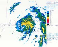
State of emergency in Florida: storm Alberto intensifies rapidly
It was on the verge of becoming the first hurricane of 2006 on Monday as it spun over the warm waters of the Gulf of Mexico and began to lash the northwest Florida shore.

Meanwhile, a front extended from the Mid-Atlantic and Tennessee Valley west into the central and southern Plains. Widely scattered showers and thunderstorms dampened the region, with the heaviest rain in the Carolinas, Arkansas and Texas Panhandle, Forbes reports.
Anxious officials ordered thousands of residents to evacuate barrier islands, flood plains and trailer parks as the storm's maximum sustained winds accelerated to near 70 miles per hour (110 kph).
The outer fringes of the storm gusted ashore with sheets of rain and forecasters at the National Hurricane Center said its core would move over northern Florida by daybreak.
Alberto could still intensify into a Category 1 hurricane on the five-step Saffir Simpson scale of hurricane intensity, he said.
Florida Gov. Jeb Bush declared a state of emergency even though the most likely area of landfall was sparsely populated swampland and farming country. The area has no big cities like New Orleans, devastated in August by Hurricane Katrina, according to Reuters.
Officials are preparing to the evacuation. 26 shelters in 16 counties have been opened for evacuees.
Subscribe to Pravda.Ru Telegram channel, Facebook, RSS!


