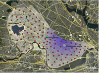
CitySense becomes another addition on location-based mobile networking
Sense Networks, a New York-based company, released its new experimental product called CitySense on Monday. The new product becomes a new addition on the market of location-based mobile networking.

CitySense has been designed to tell a lot more than just your friends’ whereabouts. The company plans to use the database of location-based information not only those subscribers who downloaded its mobile client, but also from other sources - taxicab GPS logs, for example. Sense Networks calls that mapping technology “Macrosense.”
CitySense is currently available as a free download for BlackBerry and iPhone handsets. A person using such a phone will thus be able to see locations where the most human activity is happening at the moment. When CitySense upgrades in the future, it will allow to provide even more detailed locations. However, the company is not sure yet whether it is going to be possible due to privacy concerns.
For the time being, CitySense is limited to San Francisco only. Other cities are in development.
CitySense arrives as a mobile mapping applciation that people can use to find nightlife hotspots in real time based upon their current location.
“Citysense demonstrates the power of combining anonymous, aggregate location data for social navigation,” outlined Sandy Pentland, Chief Privacy Advocate, co-founder of Sense Networks, and Director of Human Dynamics Research at MIT. “The idea is similar to automobile GPS systems sharing and pooling current road speed conditions so that everyone can avoid congestion.”
“Just as Google indexed pages on the Internet to optimize web discovery, Sense Networks has indexed the real places in a city and characterized them by activity, versus proximity or demographics, to better understand the context of consumers’ offline behavior,” explained Tony Jebara, Chief Scientist, co-founder of Sense Networks, and Director of the Machine Learning Laboratory at Columbia University.
Subscribe to Pravda.Ru Telegram channel, Facebook, RSS!


