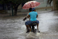
Meet Hurricane Gustav
Hurricane Gustav continued to gain strength Tuesday and forecasters said it could become a Category 2 hurricane before hitting Haiti's southern coast.

The fast-forming storm was also on track to hit Cuba.
The National Hurricane Center in Miami said the hurricane's maximum sustained winds were near 85 mph (140 kph) with higher gusts. A Category 2 hurricane has winds of 96 mph (154 kph) or higher.
Haitians were told to prepare for evacuations as the storm formed Monday in the Caribbean. Haiti upgraded storm warnings to hurricane warnings along much of its coast as Gustav closed in from the south. A warning means hurricane conditions are expected within 24 hours.
Forecasters said storm preparations in Haiti should be rushed to completion and that floods and landslides were possible across its southern peninsula. The forecasts suggested Gustav's eye could pass near the capital of Port-au-Prince, home to nearly 3 million people.
Cuba issued a hurricane watch for several provinces and Jamaica upgraded its tropical storm watch to a hurricane watch. A watch means hurricane conditions are possible within 36 hours.
At 0900 GMT Tuesday, the hurricane was centered about 100 miles (160 kilometers) south-southeast of Port-au-Prince and was moving toward the northwest at near 9 mph (15 kph).
On Monday, Carnival Cruise Lines diverted one of its ships to a Mexican port instead of Montego Bay, Jamaica, to avoid the storm, company spokesman Vance Gulliksen said. Other cruise lines said they were closely tracking its path.
After passing over Haiti, Gustav was expected to hit Cuba's southeastern tip Wednesday.
The commander of the Guantanamo military base in Cuba, where the U.S. holds about 265 men, many suspected of belonging to al-Qaida or the Taliban, ordered U.S. military personnel to prepare for a hit late Tuesday or early Wednesday.
"We're monitoring the track of ... Gustav and reviewing our destructive weather plans and procedures," said Army Maj. Richard Morehouse, a spokesman for detention operations at the base.
Vulnerable to high winds are dozens of tents pitched on an abandoned runway where those attending war-crimes trials for alleged terrorists are housed. No hearings are scheduled this week.
Morehouse told The Associated Press the lockups housing all detainees "are capable of withstanding hurricane force winds and rain."
Haitians were told to stay on alert for evacuations and to avoid crossing flooded rivers, the cause of nearly all 23 deaths on the greater island of Hispaniola during Tropical Storm Fay earlier this month.
Dominican authorities issued warnings and advised small boats to remain in port, even on the north side of the island of 17 million people.
Meanwhile, two other storms lashed the southeastern U.S. and Mexico's Pacific coast.
The remnants of Fay brought heavy rain and winds from Georgia to Louisiana. Floridians were still mopping up floodwaters from a storm that stuck around for a week and made a historic four landfalls, dumping more than 30 inches (76 centimeters) of rain along the central Atlantic coast.
The National Weather Service said the vestiges of Fay would deluge northern Georgia with 3 inches (8 centimeters) to 5 inches (13 centimeters) of rain expected in the Atlanta area and up to 8 inches (20 centimeters) in northeast Georgia. In Alabama, flash flood and tornado warnings were posted.
In Mexico, Tropical Depression Julio continued to weaken as it dumped rain on the central Baja California peninsula before heading toward the northern Gulf of California.
The hurricane center said late Monday that Julio was downgraded from a tropical storm to a tropical depression. The Mexican government lifted all tropical storm warnings.
The National Hurricane Center said Julio was about 40 miles (65 kilometers) southeast of Bahia de Los Angeles in Baja California, Mexico, and was moving north-northwest at near 7 mph (11 kph).
Subscribe to Pravda.Ru Telegram channel, Facebook, RSS!


